Home » Mexico Destinations » Rocky Point » Rocky Point Driving
Rocky Point Driving Directions Puerto Penasco
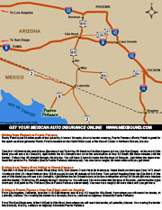
Welcome to the mexbound.com guide to driving to Puerto Pensaco - Rocky Point. Thanks to our San Diego roots, we're able to provide you with firsthand, detailed information on driving directions and maps to Rocky Point. Before you leave on your next adventure south of the border, be sure to purchase Mexican Insurance from mexbound.com. Remember, mexbound.com is "the first choice for the smart traveler." Rocky Point is just 60 miles south of the Lukeville, Arizona/Sonoyta, Mexico border crossing, Puerto Penasco (Rocky Point) is great for the quick weekend getaway! Rocky Point is located on the North West coast of the Sea of Cortez in Northern Sonora, Mexico. Rocky Point is strategically located within the Sonora Free Zone, unrestricted driving zone for vehicles coming from the US. If you are driving within the state of Sonora for 7 days or less, you don't need a permit for your personal vehicle, provided you can produce a valid driver's license or ID upon request.
Driving from Pheonix to Puerto Penasco
1. Take the I-10 West to the end of town (Buckeye Area)
2. Take Hwy 85 South to Gila Bend (same exit as I-8 to San Diego)
3. At the end of Gila Bend you will see a Mc Donald's, right before the Mc Donald's turn on to the continuation of Hwy 85 South (90 more minutes until the border).
4. Follow Hwy 85 straight through into Mexico. You will have 2 turns to make into the town of Sonoyta. Just follow the signs overhead that point to Pto. Penasco (that is Puerto Penasco abbreviated).
5. You now have roughly 60 more miles until you get there.
Driving from Tempe (East Valley) to Puerto Penasco
1. Take the I-10 East to Queen Creek Road (Hwy 347)
2. Exit Queen Creek West (to Maricopa)
3. Head South on Maricopa (Hwy 347) about 10 miles to Hwy 238
4. Head West on Hwy 238 til you get to Hwy 85 outside of Gila Bend
5. Turn Left left heading West into Gila Bend
6. At the end of Gila Bend you will see a Mc Donald's, right before the Mc Donald's turn on to the continuation of Hwy 85 South (90 more minutes until the border).
7. Follow Hwy 85 straight through into Mexico. You will have 2 turns to make into the town of Sonoyta. Just follow the signs overhead that point to Pto. Peñasco (that is Puerto Peñasco abbreviated).
8. You now have roughly 60 more miles until you get there.
Driving to Puerto Penasco from San Diego and Los Angeles
From Los Angeles, California, take the 1-10 East freeway and at exit 112 head for Gila Bend, from where you will reach the border, at Lukeville, Arizona. On crossing the border into Sonoyta, Mexico, continue on highway 8 towards Puerto Penasco.
From The San Diego area, follow I-8 East to Gila Bend, from where you will reach the border, at Lukeville, Arizona. On crossing the border into Sonoyta, Mexico, continue on highway 8 towards Puerto Penasco.
Driving Distances to Puerto Penasco - Rocky Point
- Phoenix.....215 miles
- Tucson.....216 miles
- Los Angeles.....516 miles
- San Diego.....360 miles

Download Driving Directions
to Rocky Point .PDF
The directions provided in this section are opinionated general guidelines for driving to Rocky Point Sonora, Mexico. We offer these directions, to show possible driving routes to Puerto Penasco aka Rocky Point. Highways and road conditions are constantly changing, be sure to consult a Mexico road map for official driving routes in Mexico.